
Free Charts For Bareboaters!
 NOAA, the National Oceanic and Atmospheric Administration, is using your tax dollars for a worthwhile purpose: free charts!!
If you've priced a paper chart recently and the paramedics were able to get your heart re-started, then you understand the problem. As electronic charts and chartplotters on charter boats proliferate, it's become a lot more expensive to buy paper charts of your cruising area. Most well-equipped charter boats are equipped with chart books or charts even if they have chart plotters, which is just good seamanship.
But what if you want to plan your charter before leaving home? Investing in charts or chart books that you may use only once seems pointless. NOAA now provides the answer.
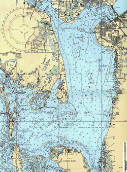
The NOAA charts that cover more than 95,000 miles of U.S. coastline are now available in the Office of Coast Survey BookletCharts. These are free printable charts in 1000 downloadable booklets. Just go to www.nauticalcharts.noaa.gov, pick the ones you want, and drop them into your computer or laptop.
I don't think I'd want to do any serious navigation with a chart made from taped-together pieces of typing paper from my home printer but, for cruise planning and backup, these can't be beat!
 Share Article →